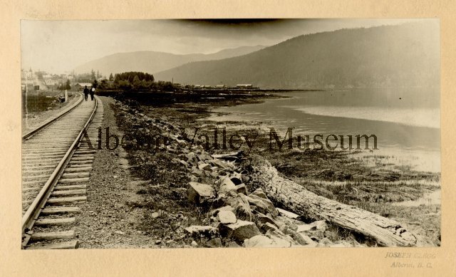
AVM Notes: “High tide of C.P.R Wye. View of railway tracks along inlet shore. Two men walking on tracks. Town buildings in background.”
Have you ever had that moment when something completely overturns what you believed before? This picture from the Alberni Valley Museum was taken on May 21, 1917 not long after the railway was built.
The “Aha” moment? There is water on *both sides* of the tracks! Now go a little further back around 1906, near the same place.
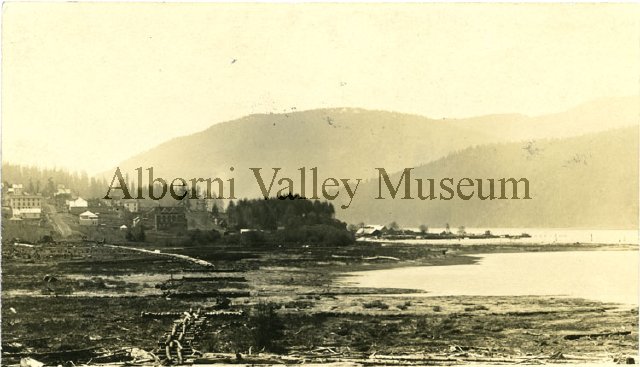
AVM Notes: “New Alberni, looking south from mouth of Dry Creek. Beach with board walk in the fore ground leads to First Avenue. Somass Hotel and King Edward Hotel can be identified. A large treed area opens up to the wharf area at the bottom of Argyle Street. Inlet and mountains in the background.”
The Lower 3rd and 4th Avenue area used to be a marshy estuary and beach at the mouth of Owatchet Creek, now commonly known as Dry Creek.
We want to restore this natural setting with all the natural, economic and community benefits that would bring.
Continue to see how it could look after restoration.
Showing the causeway built for the railway. There is water visible in the marshy parts in the middle ground of the picture. Picture is likely taken near the foot of Redford Hill. AVM Notes: Lupsi – Cupsi Point. Railway tracks. The Alberni Inlet in the background. 1912A panorama (includes the previous two images) of the entire lower 3rd Ave shoreline from Redford to Owatchet Creek the left most picture is not available online.This picture, taken from what would today be somewhere on the Catalyst paper property, shows the original railway “wye” (y shaped track to the left) that was built up along the shore of Lupsi Cupsi point on the northern side of the bay and estuary. We can see that the actual level of the land is below the railway. It may have even still flooded at this time at high tide. On the left of the picture we can see the marsh of the estuary stretching back to where the land starts to rise, likely around present day 3rd Avenue. There is marsh and water throughout the area left of the locomotive and train. There are also large logs visible in the foreground and on the left side likely marking the winter high tide mark.Panorama of the shoreline near the Somass (now Thunderbird building) showing the shoreline of the fisherman’s harbour after the railway was biult. This is outside the scope of our project, but gives an idea of what the shoreline might have looked like in the Dry Creek area.A closeup from the nautical map of the Owatchet Creek Bay and Estuary pre-1933. We can see the path of the railway through the marsh. The marsh shoreline reaches all the way to 3rd avenue on the north side. There is a small mill connected to the railway with a dock into the harboured in the middle of the marsh to the left (west) of the railway. To the right east) of the railway, land has been filled for the train roundhouse on the north bank of the creek. The marsh continues to the foot of Athol Street. There is are two small groves of trees at the foot of Dunbar (visible in the next picture). The mouth of the creek is roughly in line with Strathern. From the bottom of 1st Avenue and Athol Street. 1933. This would have been just before the construction of the Somass Mill began. We can see the railway turns to the north across Owatchet creek in line with the first/second avenue block of buildings. On the left beyond the tracks we see marsh or grass, the shrubs and trees, perhaps marking the course of the creek. There are also two groves of large trees in the centre of the picture. In the background on the left there is a mill already operating essentially in the middle of the bay marsh.A Gallery of Historic images for Dry Creek Estuary and Lower 3rd and 4th Avenues